
Introduction
GIS surveys are a powerful tool that can be used to assess natural disaster risk. By identifying areas that are vulnerable to natural hazards, GIS surveys can help communities to better prepare for and respond to these disasters.
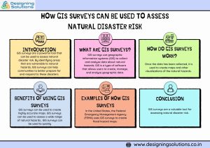
What are GIS surveys?
GIS surveys use geographic information systems (GIS) to collect and analyze data about natural hazards. GIS is a type of software that allows users to create, manage, and analyze geographic data. GIS surveys can be used to collect data about a wide range of natural hazards, including floods, earthquakes, wildfires, and landslides.
How do GIS surveys work?
GIS surveys work by collecting data from a variety of sources, including:
- Satellite imagery: Satellite imagery can be used to map the location and extent of natural hazards.
- Aerial photography: Aerial photography can be used to provide high-resolution images of natural hazards.
- Ground surveys: Ground surveys can be used to collect data about natural hazards that cannot be detected by satellite imagery or aerial photography.
Once the data has been collected, it is used to create maps and other visualizations of the natural hazards. These maps and visualizations can then be used to identify areas that are at risk and to develop mitigation and preparedness measures.
Benefits of using GIS surveys to assess natural disaster risk
There are a number of benefits to using GIS surveys to assess natural disaster risk, including:
- Accuracy: GIS surveys can be used to create highly accurate maps and other visualizations of natural hazards. This information can then be used to make informed decisions about mitigation and preparedness measures.
- Comprehensiveness: GIS surveys can be used to assess a wide range of natural hazards, including floods, earthquakes, wildfires, and landslides. This information can then be used to develop a comprehensive risk assessment plan.
- Timeliness: GIS surveys can be used to quickly and efficiently collect and analyze data about natural hazards. This information can then be used to make timely decisions about mitigation and preparedness measures.
In the United States, the Federal Emergency Management Agency (FEMA) uses GIS surveys to create flood hazard maps.
In Japan, the government uses GIS surveys to create earthquake hazard maps
These maps are used to identify areas that are at risk of earthquakes and to develop earthquake-resistant building codes.
In Australia, the government uses GIS surveys to create wildfire risk maps
These maps are used to identify areas that are at risk of wildfires and to develop wildfire prevention and suppression plans.
How to use GIS surveys to assess natural disaster risk
If you are interested in using GIS surveys to assess natural disaster risk, there are a few things you need to do:
Identify the natural hazards that are relevant to your area
This could include floods, earthquakes, wildfires, landslides, or other hazards.
Collect data about the natural hazards
This data could include topographic data, geological data, vegetation data, and historical data.
Use GIS software to create maps and other visualizations of the natural hazards
This information can then be used to identify areas that are at risk and to develop mitigation and preparedness measures.
If you do not have the expertise or resources to conduct a GIS survey yourself, you can hire a professional GIS consultant to help you.
Conclusion
GIS surveys are a valuable tool for assessing natural disaster risk. By using GIS surveys to identify areas that are vulnerable to natural hazards, communities can better prepare for and respond to these disasters.